|
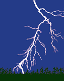
LIGHTNING
 As the particles within a cloud
(called hydrometeors) grow and interact, some become charged possible
through collisions. It is thought that the smaller particles tend to
acquire positive charge, while the larger particles acquire more negative
charge. These particles tend to separate under the influences of updrafts
and gravity until the upper portion of the cloud acquires a net positive
charge and the lower portion of the cloud becomes negatively charged. This
separation of charge produces enormous electrical potential both within
the cloud and between the cloud and ground. This can amount to millions of
volts, and eventually the electrical resistance in the air breaks down and
a flash begins. Lightning, then, is an electrical discharge between
positive and negative regions of a thunderstorm. As the particles within a cloud
(called hydrometeors) grow and interact, some become charged possible
through collisions. It is thought that the smaller particles tend to
acquire positive charge, while the larger particles acquire more negative
charge. These particles tend to separate under the influences of updrafts
and gravity until the upper portion of the cloud acquires a net positive
charge and the lower portion of the cloud becomes negatively charged. This
separation of charge produces enormous electrical potential both within
the cloud and between the cloud and ground. This can amount to millions of
volts, and eventually the electrical resistance in the air breaks down and
a flash begins. Lightning, then, is an electrical discharge between
positive and negative regions of a thunderstorm.
A lightning flash is composed of a
series of strokes with an average of about four. The length and duration
of each lightning stroke vary, but typically average about 30
microseconds. (The average peak power per stroke is about 1012
watts.)
THUNDER
|
Sound is
generated along the length of the lightning channel as the
atmosphere is heated by the electrical discharge to the order of
20,000 degrees C (3 times the temperature of the surface of the
sun). This compresses the surrounding clear air producing a shock
wave, which then decays to an acoustic wave as it propagates away
from the lightning channel. |
Although the flash and resulting
thunder occur at essentially the same time, light travels at 186,000 miles
in a second, almost a million times the speed of sound. Sound travels at
the relatively snail pace of one-fifth of a mile in the same time. Thus
the flash, if not obscured by clouds, is seen before the thunder is heard.
By counting the seconds between the flash and the thunder and dividing by
5, an estimate of the distance to the strike (in miles) can be made.
CLOUDS AND
RAIN
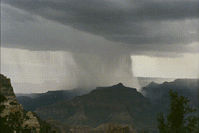 When moisture-laden warm air is
heated, it begins to rise. As these currents or bubbles of warm moist air
rise higher in the atmosphere, both the surrounding air pressure and
temperature decrease. The air bubbles expand, causing cooling of the
moisture which eventually condenses to form clouds. As the cloud cools
further, more moisture condenses and the water droplets making up the
cloud grow and merge until some become so large and heavy that the air
currents within the cloud can no longer support them. These water droplets
begin to fall as rain. When moisture-laden warm air is
heated, it begins to rise. As these currents or bubbles of warm moist air
rise higher in the atmosphere, both the surrounding air pressure and
temperature decrease. The air bubbles expand, causing cooling of the
moisture which eventually condenses to form clouds. As the cloud cools
further, more moisture condenses and the water droplets making up the
cloud grow and merge until some become so large and heavy that the air
currents within the cloud can no longer support them. These water droplets
begin to fall as rain.
HAIL
 Air currents in cumulonimbus clouds can be
very violent. Even when lightning is not produced, pellets of ice may grow
by the accumulation of liquid droplets. When the updrafts are very strong,
the growing ice pellets can be suspended for long periods, allowing them
to grow larger. Eventually some may become too large for a given updraft
and begin to fall as hail. Diameters are typically 5 to 10 mm, although a
l40 mm hailstone has been recorded. Air currents in cumulonimbus clouds can be
very violent. Even when lightning is not produced, pellets of ice may grow
by the accumulation of liquid droplets. When the updrafts are very strong,
the growing ice pellets can be suspended for long periods, allowing them
to grow larger. Eventually some may become too large for a given updraft
and begin to fall as hail. Diameters are typically 5 to 10 mm, although a
l40 mm hailstone has been recorded.
THE MOST
COMMON TYPES OF LIGHTNING
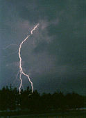 Cloud-to-ground
lightning is the most damaging and dangerous form of lightning.
Although not the most common type, it is the one which is best understood.
Most flashes originate near the lower-negative charge center and deliver
negative charge to Earth. However, an appreciable minority of flashes
carry positive charge to Earth. These positive flashes often occur during
the dissipating stage of a thunderstorm's life. Positive flashes are also
more common as a percentage of total ground strikes during the winter
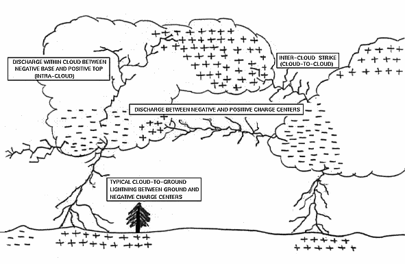
months. Cloud-to-ground
lightning is the most damaging and dangerous form of lightning.
Although not the most common type, it is the one which is best understood.
Most flashes originate near the lower-negative charge center and deliver
negative charge to Earth. However, an appreciable minority of flashes
carry positive charge to Earth. These positive flashes often occur during
the dissipating stage of a thunderstorm's life. Positive flashes are also
more common as a percentage of total ground strikes during the winter
months.
Intra-cloud lightning is the most common type of
discharge. 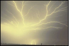 This occurs between oppositely
charged centers within the same cloud. Usually the process takes place
within the cloud and looks from the outside of the cloud like a diffuse
brightening which flickers. However, the flash may exit the boundary of
the cloud and a bright channel, similar to a cloud-to-ground flash, can be
visible for many miles. This occurs between oppositely
charged centers within the same cloud. Usually the process takes place
within the cloud and looks from the outside of the cloud like a diffuse
brightening which flickers. However, the flash may exit the boundary of
the cloud and a bright channel, similar to a cloud-to-ground flash, can be
visible for many miles.
The ratio of cloud-to-ground and
intra-cloud lightning can vary significantly from storm to storm. Storms
with the greatest vertical development may produce intra-cloud lightning
almost exclusively. Some suggest that the variations are
latitude-dependent, with a greater percentage of cloud-to-ground strikes
occurring at higher latitudes. Others suggest that cloud-top height is a
more important variable than latitude.
Details of why a discharge stays within
a cloud or comes to ground are not understood. Perhaps a flash propagates
toward the Earth when the electric field gradient in the lower regions of
the cloud is stronger in the downward direction.
Depending upon cloud height above
ground and changes in electric field strength between cloud and Earth, the
discharge stays within the cloud or makes direct contact with the Earth.
If the field strength is highest in the lower regions of the cloud a
downward flash may occur from cloud to Earth.
Inter-cloud lightning, as the name implies, occurs
between charge centers in two different clouds with the discharge bridging
a gap of clear air between them.
OTHER TYPES OF LIGHTNING
There are numerous names and descriptions of various types
and forms of lightning. Some identify subcategories, and others may arise
from optical illusions, appearances, or myths. Some popular terms include:
ball lightning, heat lightning, bead lightning, sheet lightning, silent
lightning, black lightning, ribbon lightning, colored lightning, tubular
lightning, meandering lightning, cloud-to-air lightning, stratospheric
lightning, red sprites, blue jets, and elves.
DESCRIPTION OF LIGHTNING DISCHARGE
PROCESSES
With the initial
breakdown of the air in a region of strong electric fields, a streamer may
begin to propagate downward toward the Earth. It moves in discrete steps
of about 50 meters each and is called a stepped leader. As it grows, it
creates an ionized path depositing charge along the channel, and as the
stepped leader nears the Earth, a large potential difference is generated
between the end of the leader and the Earth. Typically, a streamer is
launched from the Earth and intercepts the descending stepped leader just
before it reaches the ground. Once a connecting path is achieved, a return
stroke flies up the already ionized path at close to the speed of light.
This return stroke releases tremendous energy, bright light and thunder.
Occasionally, where a thunderstorm grows over a tall Earth grounded
object, such as a radio antenna, an upward leader may propagate from the
object toward the cloud. This "ground-to-cloud" flash generally transfers
a net positive charge to Earth and is characterized by upward pointing
branches.
 |
| The lower part of a thundercloud is usually
negatively charged. The upward area is usually positively charged.
Lightning from the negatively charged area of the cloud generally
carries a negative charge to Earth and is called a negative flash. A
discharge from a positively-charged area to Earth produces a
positive flash. |
The initial
breakdown and propagation are similar for intra-cloud lightning, but the
discharge generally occurs between regions of opposite charge. Without the
benefit of air conducting Earth, intra-cloud lightning does not produce a
return-stroke-like feature. Rather, it is characterized by slower
propagating "recoil streamers" and "K" changes. Nevertheless, tremendous
energy, bright light, and thunder are still produced by intra-cloud
lightning.
|
